|
|
|
|
|
|
|
|
|
|
|
|
|
|
|
|
|
|
|
|
|
|
|
|
|
|
|
|
|
|
|
Welcome
To The Kumeu District
The Fruit Bowl of Auckland
|
|
|
|
|
|
|
|
|
|
|
|
|
|
|
|
|
|
|
|
|
|
|
|
|
The Kumeu District is known for:-
- Fruit Orchards
- Intensive Horticulture
- Vineyards & Wineries
- Restaurants
- Sheep & Beef Farming
- Rural Lifestyle Blocks
- Pine Forests with access for public recreation
- Equestrian Activities
- Outdoor Pursuits
- The Wild West Coast Beach of Muriwai with its Black Iron Sands, over 30 km long, great for fishing, surfing, land yachting, horse riding, kite flying etc.
- Gannet Colony With
Easy Public Viewing. See Paul Hafner's "Gannets at Muriwai"
|
|
 |
|
|
|
|
|
|
|
|
|
|
|
|
|
|
|
|
|
|
|
|
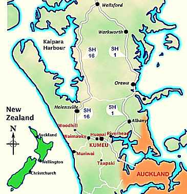
Kumeu-Huapai
The commercial and business hub of the district with two shopping centres, building
and hardware retailers, three banks, professional services, bars and restaurants
it is
" THE centre" of the district in all respects. All this as well as vineyards,
orchards and craft shops, is only 26 kilometres from the centre of Auckland
on State Highway 16. In March each year the Kumeu Showgrounds holds one of the
southern hemisphere's biggest one-day shows. A variety of other cultural festivals
and events take place in the grounds throughout the year. The district is well
known as a centre for breeding and training standard-breds (horses) as well
as being a strong competitive equestrian district. Kumeu-Huapai is also a thriving
industrial area. It's businesses support and service many industries including
forestry, construction, heavy transport, engineering, marine and viticulture
to name but a few. There are numerous outdoor locations which provide great
venues for special family events or larger scale television and film settings.
Come out West - there's lots of the best !
Back to top Local Area Map
|
|
|
Muriwai
A spectacular west coast beach that is world renowned for its surf and
black sand, and is over 30 kilometres long. It is also home to one of
New Zealand's few gannet colonies unique because it is accessible to the
whole family - only a few minutes easy walk from a car park area. Muriwai
also has its own 18-hole all weather golf club nestled between Woodhill
forest and the beach. There is a great motor camp, surf life saving club
as well as two shops and a small motel. Everything to make this a great
place to escape from the city any time of the year. Goldie's Bush, just
a few minutes up the road offers a fascinating walk amongst real New Zealand
native bush. Numerous kauri trees overlook your progress as you criss-cross
Mokoroa stream.
Back to top Local Area Map
|
|
|
|
|
|
|
|
|
|
|
|
|
|
|
Woodhill
At the northern edge of the district is the large Woodhill radiata pine forest.
The forest setting is renowned for a variety of recreational activities such
as orienteering, moto-x, mountain biking and horse trekking. (Permits available
from Forest HQ) Away from the forest is a traditional New Zealand rural environment
with horticulture, dairy, sheep and beef farms.
Back to top
|
|
|
|
|
|
|
|
|
|
|
Waimauku
Located at the junction of SH16 and Muriwai Road this is an attractive lifestyle
village. Great country living with everything you need - primary school, playcentre,
day-care centre, medical centre service station plus shops. Several road-side
outlets also offer a variety of fresh fruit and vegetables - healthy " food
on the go " as you seek out another adventure in the west. There is also a
great function centre offering venues for weddings or other gatherings in
an historic building. Just over the hill is another first class restaurant
located in a renowned vineyard. One of many in the district.
Back to top Local Area Map
|
|
|
|
|
|
|
|
|
|
|
|
|
|
|
|
|
Riverhead
One of the oldest established communities in the west on the banks of the
Rangitopuni River. The township derives its name from the fact that it is
at the upper limit of the waitemata harbour that the early settlers were able
to sail as they explored the river and its surrounding bushland. A museum
also offers an insight to the history of its early European settlers. With
a school, rugby club, shops and a busy community centre it is classic "small
town" New Zealand.
Back to top Local Area Map
|
|
|
|
|
|
|
|
|
|
|
Web
design by Steno |
|
|
|
|
|
|
|
|
|
|
|
|
|
|
|
|
|
|
|
|
|
|
|
|
|
|
|
|
|
|
Taupaki
A peaceful rural village with a strong sense of history in the areas development.
It is only a few minutes from the Waitakere Railway station where the city
commuter line ends. A community based around lifestyle blocks there is a primary
school and a retirement home to ensure all stages of life are catered for
!
Back to top
|
|
|
|
|
|
|
|
|
|
|
|
|
|
|
|
|
|
 |
|
|
|
|
|
|
|
|
|
|
|
|
|
|
|
|